

Protecting and restoring wetlands
Wetlands are our climate adaptation hero and provide a range of important ecosystem services!
Our position in a nutshell
Wetlands are among the most important ecosystems on Earth (Clarkson 2004) but Aotearoa New Zealand unfortunately has one of the highest rates of wetland loss in the world (Clarkson et al 2013).
Wetlands provide a disproportionately high level of ecosystem services for the small area of land that they cover, including numerous social and economic benefits for communities (Clarkson et al 2013). Wetlands support a greater concentration of wildlife species than any other native habitat in Aotearoa New Zealand (DOC 2021). They cycle nutrients and manage carbon (including carbon storage), can improve water-quality, and are natural flood and drought buffers, taking in water like a sponge and regulating its movement (Clarkson et al 2013).
Wetlands often hold important cultural significance for Māori and are valued as places that provide spiritual connections. They are valued for mahinga kai, taonga species and important medicinal plants for rongoā (Māori medicinal use) (Taura et al 2017).
The NPS-FM requires you to include objectives, specific policy wording and methods in your regional plans to protect and restore the extent of wetlands and the values that natural inland wetlands have (NPS-FM 3.21 (1)), but this is a bare minimum requirement (see NPS-FM 3.22).
You will need to do more than is specified in the NPS-FM to implement Policy 6 by including attributes and target attribute states for wetlands in your regional plans. We expect the Wetland Condition Index (WCI) to be included. We want to see each region aim to restore wetland cover to at least 20 percent of its original extent, improve the wetlands’ condition to a score greater than 10 on the WCI and prevent any further reductions in the extent of existing wetlands.
Why are wetlands so impressive?
We want you and the community to implement the NPS-FM in a way that is positive and brings the community along with you. You will need great, tangible examples to communicate its purpose, importance, and benefits to a range of different people to encourage effective freshwater management by all New Zealanders (as per NPS-FM 1.3(3) and (4)).
Having plan provisions that promote wetland protection and restoration is an opportunity to positively engage with the community, as wetlands support our climate change efforts and provide win-win benefits to the environment and our society.
The effects of climate change have been felt severely in Aotearoa New Zealand, which has seen significant climate-related events result in devastating costs to human life and livelihoods. But wetlands can help tell and deliver our emissions reduction and climate adaptation stories.
Wetlands play a vital role in both taking up carbon through sequestration in the bid to reach our climate goals, and in helping build community resilience to natural events that are being escalated by the changing climatic trends.
Because many freshwater wetlands are highly productive and have waterlogged conditions, they can become significant carbon (CO2) sinks and store this greenhouse gas in organic matter such as vegetation, soil, and sediments. Decarbonisation works when CO2 is taken up through plant photosynthesis (a plant’s natural growing process using sunlight, water, and CO2) and removed from earth’s atmosphere. The more wetland environments, the more CO2 that can be stored to support our climate efforts. Peat wetlands are of significant value for this.
Wetlands are also a nature-based solution to managing the movement of freshwater. For example, flood flows are an important part of natural river systems processes in Aotearoa New Zealand and wetlands form natural buffers to flood events through their ability to absorb and more slowly release water from their systems. A wetland will also filter out sediment and nutrients within its natural range to help regulate water quality (although too much sediment and nutrients can overload a wetlands ability to function normally). Conversely, during droughts, wetlands can be ‘oases’ and slowly release stored water back into the surrounding environment, buffering drought impacts.
Wetlands support healthy freshwater ecosystems and hold important value for people through their multitude of functions. They provide habitat for many threatened and endangered species, improve water quality, hold important taonga species and help produce resources such as weaving materials like raupo and harakeke. Healthy wetland environments are a sign of a thriving ecosystem and the diverse values that they can provide are well documented.
Any further loss in wetland extent or condition will have further detrimental impacts on the environment and society so make them your superpower by protecting and restoring their conditions and their extent.
The NPS-FM directive
Wetlands are a type of freshwater body, defined in the Resource Management Act 1991 as ‘permanently or intermittently wet areas, shallow water, and land water margins that support a natural ecosystem of plants and animals that are adapted to wet conditions’. Wetlands are critical habitat for species and contribute to wider ecosystem functions and ecosystem health. See the ‘Protecting water bodies and freshwater ecosystem health’ practice note for more on this.
Policy 6 of the NPS-FM states that you must avoid any further loss of natural inland wetlands (NPS-FM 3.21 (1)). Policy 6 also directs you to actively promote wetland restoration, and this will help to achieve the values and environmental outcomes identified for your Freshwater Management Unit (FMU) or part of FMU.
You must identify, map, and create an inventory of natural inland wetlands within 10 years of the commencement date of the NPS-FM (NPS-FM 3.23). You must develop and undertake a monitoring plan that includes the condition and extent of wetlands, and methods to respond if loss of extent or values is detected.
As an absolute minimum, you must include a policy in your regional plan that reflects clause 3.22 of the NPS-FM (Natural inland wetlands) – you may use different words as long as they have the same effect. You should also include any other objectives and policies that will give effect to Policy 6.
The National Environmental Standard for Freshwater (NES-F) strictly regulates all activities in or near wetlands. The regulation also identifies some activities which have a more lenient activity status such as specified infrastructure, quarrying and urban development. A very structured assessment is required that tests these activities against alternative options, before determining if an activity should be granted a resource consent. One of these tests is the ‘effects management hierarchy’ (EMH), which is outlined in Clause 3.21 – ‘Definitions relating to wetlands and rivers’ of the NPS-FM.
The EMH requires effects to be avoided first, and then minimised, and then remedied before considering any off-set or compensation mitigation. If adverse effects cannot be avoided, minimised, or remedied and one must look to off-set or compensate for loss of wetland extent, then a second set of tests must be met. This structured framework involves an in-depth assessment against the principles for aquatic offsetting (Appendix 6 of the NPS-FM) or the principles for aquatic compensation (Appendix 7 of the NPS-FM). The activity must comply with the first six principles for aquatic offsetting and the first six principles for aquatic compensation (respectively) and have regard to all other principles identified as appropriate.
Your regional plan must not allow an activity to be granted without an application first demonstrating how the EMH will be applied to any loss of extent or values of wetland, including how the aquatic offsetting or aquatic compensation is applied. The only way to achieve Policy 6 of the NPS-FM is to ensure the activity meets these strict assessment frameworks. The NES-F has also expressly stated that a regional rule may be more stringent than these regulations (Regulation 6 NES-F). You must justify why a proposed rule needs to be more stringent in the context of your region through your section 32 evaluation.
Mahinga kai is a compulsory value of the NPS-FM and wetlands (repo in te reo Māori) are often mahinga kai sites (Taura et al 2017). Mahinga kai sites should be places where no one becomes sick from eating kai harvested in a FMU or part of an FMU. Mahinga kai directly reflects the overall health and well-being of that freshwater body.
There are currently no attributes for wetlands in the NPS-FM, but you must identify and include them in your regional plan for each wetland value (NPS-FM 3.7). You will need to set target attribute states that protect and restore wetlands. Target attribute states will also need to provide for mahinga kai as a compulsory value.
What do we want to see?
We want to see wetlands promoted as your climate hero, as well as for the range of other win-win benefits they provide. They can easily become a positive engagement story when you take action to improve them, and we explained why they are so impressive in the textbox above.
We do not want to see wetland values or extent reduce any further. Wetlands once occupied nine percent of Aotearoa New Zealand’s land mass (approximately 2.4 million hectares), however it is estimated that only about 10 percent of the original extent of those wetlands exist today (now only 240,000 hectares), largely due to drainage and clearing for other land use activities (Roberston et al., 2016). As a result, some wetlands have either collapsed entirely or are now on the brink of collapse (STAG, 2019).
We want to see the extent of wetlands identified and mapped in your regional plan. You will need to determine target attribute states to maintain and improve wetland extent, and we want to see these set at least at 20 percent of the original extent of wetland in each region to address the high degree of wetland lost in Aotearoa New Zealand to date. The STAG report recommended 10 percent but given the extent of wetland crisis and their important role in ecosystem health (see Forest & Bird), 20 percent is a more ambitious national target that is necessary to address the degree of degraded wetlands. Table 1 in the Implementation Toolbox below provides an example of how you could set out an attribute table for wetland extent, with a note that we would expect the national bottom line to be set at 20 percent, rather than 10 percent.
Not all wetlands are the same and there are a variety of wetland types. Identifying each type of wetland helps you to better understand, manage, and monitor which conditions support certain wetland types and which species are compatible to live and thrive there. The main classes of wetland are bog; fen; swamp; marsh; seepage; shallow water; ephemeral wetland; pakihi and gumland and saltmarsh (Johnson & Gerbeaux, 2004) (see some examples of wetland types in the Toolbox below). Wetlands are formed and therefore classified by diverse factors such as landform setting, origins, substrates, hydrology, nutrient status, and vegetation (Johnson & Gerbeaux, 2004). We expect you to identify existing wetland type and evaluate the specific conditions required for that type, so they can be managed for their different needs.
The Wetlands Condition Index (WCI) is the best available and most comprehensive tool that Aotearoa New Zealand has to determine the state of existing wetlands. It is an attribute because it is a set of science-based indications that monitor the condition of Aotearoa New Zealand’s estuarine and palustrine wetlands (Clarkson et al., 2004). The indicators have been developed using soil and vegetation characteristics, which follows the international trend. WCI requires an assessment of a wetland against a numerical scoring system to provide a composite index of natural character. It was developed for managers, landowners, community groups and anyone else involved in monitoring the condition of wetlands so is usable for a wider range of users.
We want to see the WCI identified as an attribute in your regional plan and target attribute states set above 10 on the WCI. Table 2 in the Implementation Toolbox below provides an example of how you could set out an attribute table for Wetland Condition Index.
The significant ecological value of wetlands cannot be overstated. The better the wetland condition, the greater it can support ecosystem health (Johnson & Gerbeaux, 2004). Flora and fauna have adapted to survive in these specific but diverse environments because wetlands meet the distinct needs, tolerances, and competitive ability of these species (Johnson & Gerbeaux 2004). However, through human induced disturbances and over short timeframes, biological changes to community structures, ecological processes and functions will occur. These changes can dictate which plant and animal species are able to live in certain wetland types and will often eliminate more sensitive species. Altering wetland functions, structures and processes can irreversibly change the wetland type, further reducing the extent of wetland cover in Aotearoa New Zealand.
We want to see land use activities managed to avoid any further wetland being lost or their condition degraded.
Wetlands have also been well recognised to improve water quality through their function to denitrify water and remove sediment (Johnson & Gerbeaux 2004). Wetlands are sometimes termed the ‘kidneys’ of the water system, but like kidneys, wetlands can become overwhelmed in their capacity to process toxins (Taura et al, 2017). They cannot continually absorb pollutants and when they are physically damaged, they can become dysfunctional or stop functioning altogether.
To avoid unnecessary stresses and the loss of any further wetland extent, you will need to specify limits in your regional plan that manage the specific conditions a wetland type requires to function as part of a healthy ecosystem.
Key attributes that you will need to include and set as target attribute states are:
environmental flows and levels (i.e., surface and ground water levels) within a healthy range for specific wetland type and that do not exacerbate water quality or quantity impacts (see the ‘Environmental Flows and Levels, and Take Limits practice note when available);
nutrient status (Total Phosphorous and Total Nitrogen), with specific numbers within a healthy range for the specific wetland type (see the Setting in stream Nutrient Outcomes practice note);
inputs of external sediment within a healthy range for the specific wetland type (see the Setting sediment target attribute states practice note);
vegetated riparian margins and setbacks for stock exclusion from all wetlands and their margins (see Managing riparian margins and stock exclusion practice note, when available);
upstream fertiliser application limits within a healthy range for the specific wetland type (see Input Control practice note when available) .
Like all freshwater ecosystems, wetlands do not have a distinctive boundary. They are dynamic systems that interact and can change naturally over time (Johnson & Gerbeaux, 2004). You will need to take an integrated approach, ki uta ki tai (NPS-FM 3.5), to managing wetlands as part of healthy and functioning ecological communities, and the surrounding environment. For example, wetlands are highly sensitive receiving environments where water, sediment and nutrients can accumulate (Clarkson et al, 2004). At levels that are too high, accumulations can overwhelm certain wetland types to a point where they can no longer support the natural range of species that have adapted to live there.
TASs for a wetland’s catchment need to be set at levels that will support the health of identified wetlands and their values. You will also need to set nutrient outcomes in upstream waterbodies that will achieve ecosystem health in downstream wetlands as nutrient sensitive receiving environments.
How should the NPS-FM be implemented?
Map wetland extent in your regional plan
Wetland extent needs to be an attribute in your regional plan. As mentioned above, an example of this can be found in Table 1 in the Implementation Toolbox below. It is critical that you understand what existing wetland area you have in your region so that you can protect what you already have and actively restore at least 20 percent of original wetland back to your region.
Map the extent of your wetland area using a spatial tool such as a Geographic Information System (GIS). The Ministry for the Environment has a tool which can assist in predicting wetland extent before humans arrived in Aotearoa New Zealand at: https://data.mfe.govt.nz/layer/52677-prediction-of-wetlands-before-humans-arrived/.
Methods for mapping current and historical wetland extent in Aotearoa New Zealand are available and can be found in a report for the Southland Region (Landcare Research, 2011). These are supported by an Aotearoa New Zealand specific paper on quick mapping and prioritisation methods for wetland types (Ausseil et al., 2007).
You can also prioritise wetland restoration efforts using the methodology outlined in the paper titled ‘Ranking wetland ecosystems of national importance for biodiversity: criteria, methods, and candidate list of nationally important inland wetlands’ (Ausseil et al., 2008).
Use the Wetland Condition Index
The Wetland Condition Index is the best tool available to determine the condition of wetlands in your regional plan (and was recommended by the MfE Science and Technical Advisory Group (STAG)). This is supported by the ‘Handbook for monitoring wetland condition’ (Clarkson, 2004) which should be used as the methodology to assess and monitor wetland condition, in conjunction with the attribute table shown in the example section of this practice note at Table 2.
Monitor wetlands
Monitoring is a critical part of protecting existing wetland extent and planning to restore future wetland areas. A spatial data inventory will need to be developed using aerial photography as a baseline for all wetland identified in the region. This baseline can then be used to monitor change in extent.
Likewise, a conditions assessment should be undertaken 5-yearly or more regularly as needed to monitor improvement or decline of wetland condition (STAG, 2019). Appropriate management action will then need to be implemented to meet the target attribute state of wetlands, as identified in your regional plan.
Identify Mahinga Kai locations under mana whenua guidance
Mahinga kai describes the physical place where indigenous freshwater species live and where traditional activities to harvest, collect, hunt, and gather kai (food) and resources are undertaken (Collier et al., 2017). It is also a place that provides opportunity to transfer important customary knowledge of kai preparation, storage, and cooking to current and future generations (Taura et al., 2017).
You will need to identify areas in FMU or parts of FMU that are valued for providing mahinga kai.
Determining how this is done will need specific engagement and established relationships with those who can provide guidance on tikanga and culturally appropriate methods of identifying and recording mahinga kai locations. Together with mana whenua, you will need to set target attribute states in your regional plan for achieving the freshwater environmental outcomes of mahinga kai as a compulsory value.
The Te Reo O Te Repo: The voice of the wetland (Taura et al., 2017) is a resource that can support this kaupapa.
Protect wetlands through more stringent rules than the Stock Exclusion Regulations and NES-F
The Stock Exclusion Regulations provide minimum requirements to exclude some stock from some wetlands. Stock must be excluded from:
any natural wetland identified in a regional or district plan or regional policy statement,
any wetland that supports threatened species,
and any wetland larger then 0.05 ha on low slope land (identified in maps associated with the regulations).
Regional plan rules can be more stringent than the Stock Exclusion Regulations (Regulation 19), so your plan can contain rules that apply to more types of animals (e.g. sheep), more waterbodies (e.g. small wetland waterbodies), on more land (e.g. land steeper than 5 degrees) and to apply setbacks (the Stock Exclusion Regulations do not require a setback from wetlands).
You should set back sediment generating activities at least 10 – 20 metres from wetlands to keep sediment from entering wetland environments. You must also ensure environmental flows are managed so that sediment moves through the water system naturally.
Nutrients entering wetlands must be within a health level for that wetland type. Too much nitrogen and phosphorous, for example, will change the type of the water body which can irreversibly change the type of wetland and the habitat, impacting the type of species that can live there.
The National Environmental Standards for Freshwater (NES-F) also set minimum standards for activities in and around wetlands – including vegetation clearance, earthworks, water takes, and drainage. The NES-F still provides for wetland clearance for quarrying, landfills and clean fills, mining, urban development, ski field infrastructure, and water storage infrastructure (e.g., dams), but this must go through the strict EMH test outlined in the NPS-FM directive above.
To get the greatest benefits from the existing wetlands you have, your plan should set stronger minimum standards than the NES-F to ensure there is ‘no net loss’ of wetlands.
You should avoid activities such as mining in wetlands to preserve the carbon sequestration functions of wetlands.
You should avoid urban development in wetlands to ensure you don’t put future communities in harm’s way by locating them in potential flood zones.
You should promote wetland areas to help retain the water storage capacity of wetlands, that can help to manage the effects of climate change.
These benefits will pay off if you include stronger provision in your regional plan than is required by the NES-F.
While the NES-F requires offsets and compensation for any wetland extent that is lost, trying to recreate the values that are lost will be extremely difficult to achieve elsewhere. This is because ecosystems are extremely complex and cannot simply be ‘recreated’, as explained below (Hilderbrand et al., 2005).
“Using recent reviews of the restoration ecology literature, we examine the effectiveness of restoration as an approach for offsetting biodiversity loss, and conclude that many of the expectations set by current offset policy for ecological restoration remain unsupported by evidence.” Faustian bargains? Restoration realities in the context of biodiversity offset policies” (Maron et al., 2012).
“We have little ability to predict the path that sites will follow when restored in alternative ways, and no insurance that specific targets will be met.” Progress in wetland restoration ecology” (Zedler, 2000).
“Multi-million-dollar mitigation agreements have been based on the expectation that damages to habitat will be compensated within 5–10 years, and monitoring periods have been set accordingly. [After 12 years] … changes indicate little chance that targets will be reached in the near future” (Zedler & Callaway, 2002).
Restoration or recreation of ecosystems through offsets and compensation is also extremely costly (Budiharta et al., 2018). Your plan should do everything it can to preserve the wetlands that remain as they are effectively irreplaceable.
The NES-F wetland provisions are currently being challenged in the High Court by Forest & Bird on the basis that they did not implement the objectives and policies of the NPS-FM, and because they are not in accordance with Part 2 of the Resource Management Act 1991. Forest & Bird also say that the coal mining consent pathway is not consistent with statements made in the decision-making documents about climate change matters (see Forest & Bird Legal Proceedings).
How we know the NPS-FM is being achieved
No more wetlands will be lost or reduced in extent from present day and your region will have at least 20 percent of its original wetland area restored (or show evidence of steps towards achieving that percentage). Wetlands will be protected, and restoration will be driven through the provisions in your regional plan. The mauri of places that support mahinga kai will thrive and ‘desired species are plentiful enough for long-term harvest and the range of desired species is present across all life stages’ (NPS-FM Appendix 1A-C).
Implementation Toolbox
The toolbox will continue to be developed as new evidence, tools, case studies, resources and examples to implement the NPS-FM become available.
Tools: are helpful diagrams, processes, or ways to support how you should implement the NPS-FM.
Examples: provide text suggestions to help draft objectives (values and environmental outcomes), policies, and rules (limits) in your regional plans, including how and monitoring could be achieved. It includes examples of how attributes and base line states, target attribute states, environmental flows and levels, and other criteria, where appropriate, can be written or presented help to achieve environmental outcomes.
Case studies: illustrate where the NPS-FM has been well applied (or not) throughout the country and provides national or international lessons to help implement the NPS-FM.
Evidence: provides relevant case law to support how the NPS-FM must be applied.
Resources: provide links to supporting literature and best information available to implement the NPS-FM.
Tools
Definition of wetland types:
Bog wetlands: Bog wetlands are nutrient poor, poorly drained and aerated, and usually acid. The water table is often close to or just above the ground surface, with rainwater the only source of water. These wetlands are dominated by indigenous vegetation that is representative of bogs in the Waikato, including peat forming plant species.
Fen wetlands: Fen wetlands are of low to moderate acidity and fertility and the water table is usually close to or just below the surface. These wetlands are dominated by indigenous vegetation that is representative of fens in the Waikato, including species adapted to low nutrient environments, such as sedges.
Swamp wetlands: Swamp wetlands are generally of high fertility, receiving nutrients and sediment from surface run-off and ground water. These wetlands are dominated by indigenous vegetation that is representative of swamps in the Waikato, including vegetation cover that is often intermingled.
Marsh wetlands: Marsh wetlands are mineral wetlands with good to moderate drainage that are mainly groundwater or surface water fed and characterised by fluctuation in the water table. Marsh wetlands can be differentiated from swamp wetlands by having better drainage, generally a lower water table and usually more mineral substrate and higher pH.
Te Reo o Te Repo: The voice of the wetland
Te Reo o Te Repo – the Voice of the Wetland is an online wetland handbook created collaboratively between the Waikato Raupatu River Trust and Manaaki Whenua-Landcare Research, and funded mainly by the Ministry of Business, Innovation and Employment (MBIE) Wetland Restoration Programme. Source: https://www.landcareresearch.co.nz/publications/te-reo-o-te-repo/
Handbook for Monitoring Wetland Conditions
This handbook covers the detail required to undertake an assessment of the WCI, including:
The approach and process involved in developing the indicators.
A detailed description of each indicator and how to assign a value and tally scores to analyse the results.
How the indicators can be used to answer a range of monitoring questions.
How the science-based indicators relate to the other objectives and products of the Co-ordinated Monitoring of New Zealand Wetlands Project.
Forest & Bird: Every Wetland Counts
This resource outlines six actions that will significantly boost the ability of New Zealand’s wetlands to help mitigate climate change impacts for the benefit of people, nature, and the planet.
Areas of historic wetland that are now grass but still in public ownership
For World Wetlands Day 2023, Forest & Bird commissioned some mapping showing the areas of predicted historic wetland that are now grass but which remain in public ownership. These are areas of land that could readily form part of the area needed in your region for wetland restoration, without facing land ownership barriers. The map overlay is available on the Koordinates mapping platform, and a short report will be released soon (Mapping of historic wetland that are now grass but still in public ownership Sept 2022).
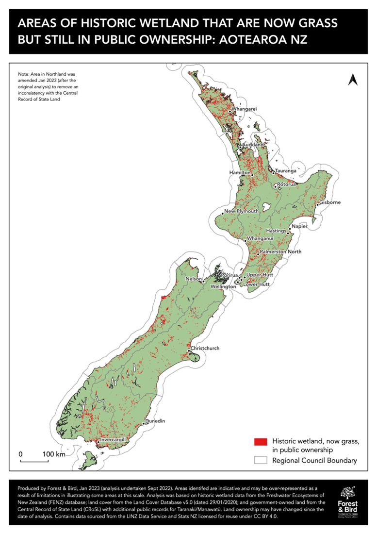
Figure 1: Areas of historic wetland that are now grass but still in public ownership.
Examples

Table 1:
Example of attribute table for wetland extent (STAG, 2019).

Make it stand out
Table 2:
Example of attribute table for Wetland Condition Index (WCI) (STAG, 2019).
Case studies
Restoring Whangamarino Wetland
Whangamarino wetland is one of Aotearoa New Zealand’s largest wetlands, which was drained and modified for flood control. This has damaged the health of the wetland and its inhabitants who rely on this important habitat to survive. Introduced flora and fauna species have also outcompeted the fragile native species and habitats.
Work has begun to maintain and enhance this wetland habitat, especially the highly threatened bog and fern wetlands. This has included habitat enhancement, weed control, predator trapping and water level and quality monitoring to better inform people about how the wetland system functions and the impact of land use activities on the environment.
Partnerships with organisations have supported this work and have provided knowledge sharing towards their vision that this place ‘remains an outstanding site for promoting the values of wetlands and species conservation, especially Australasian bittern/matuku-hūrepo’.
Grazing land out to pasture at QEP and Kaitoke, permanent carbon sink to take its place
Significant sections of Queen Elizabeth Park near Wellington have been retired from grazing to allow the historic wetland to revert back into wetland. Greater Wellington Regional Council has undertaken the initiative as a nature-based solution to help absorb carbon emissions and improve the park for the community.
The project includes restoring 128.5 hectares of peatland and duneland – the largest restoration project of its kind in Aotearoa New Zealand.
Evidence
[When available]
RESOURCES
[When available]