

Protect the habitat of indigenous freshwater species
Protect indigenous freshwater species habitat from the mountains to the sea!
Our NPS-FM position in a nutshell
Aotearoa has some of the most endangered freshwater habitats and species in the world (Koolen-Bourke & Peart, 2021; Joy et. al., 2019).
Many indigenous freshwater species are highly mobile, and they have broad habitat requirements from the mountains to the sea. Freshwater species include all birds, invertebrate (including stygofauna (NIWA, 2014)), plants and fish that live in and are supported by freshwater ecosystems. Their habitat is diverse and includes a variety of water body types such as lakes, rivers, streams, wetlands, estuaries, springs, groundwater, and their connection out to coastal waters.
You must protect all habitat that indigenous freshwater species migrate to, live, and spawn in, and need to forage, hide, and survive throughout their lifecycle (NPS-FM Policy 9).
Freshwater fish require fish passage and good habitat all year round and across the entire length of freshwater body systems because native fish migration and spawning timeframes range across most of the calendar year (Smith, 2014).
The NPS-FM directive
Policy 9 of the National Policy Statement for Freshwater Management directs you to protect the habitat of indigenous freshwater species.
In Appendix 1A of the NPS-FM, habitat is one of the five ecosystem health components and is defined as ‘the physical form, structure, and extent of the water body, its bed, banks and margins; its riparian vegetation; and its connections to the floodplain and to groundwater’. However, Policy 9 goes beyond habitat defined by its physical form and can be interpreted more broadly as a wholistic term that is ‘the sustaining ecosystem upon which taxon depends’ (Townsend et al., 2008, p. 32).
This means protecting habitat may include all the physical, biotic and resources available in the area to support a species survival and reproduction. Habitat in this context could include all five components that contribute to ecosystem health (NPS-FM Appendix 1A) - water quality; water quantity; habitat; aquatic life and ecological processes. Therefore, you should think about all five ecosystem health components across all waterbody types to implement Policy 9.
Freshwater habitats are not discreet locations, they are interconnected and interdependent. Integrated management is specifically directed in the NPS-FM through the concept of ki uta ki tai as required by Te Mana o te Wai. In its broadest sense, you must recognise the interactions and interconnectedness of freshwater ecosystems, their connection to receiving environments, including the coastal environment, and the mountains-to-sea lifecycles of many indigenous freshwater species. The NPS-FM requires you to provide for fish passage, and preparing fish passage action plans is a critical component of protecting the habitats of indigenous species (NPS-FM 3.26).
Threatened species is a compulsory value that you must identify in your regional plan. Threatened species includes all indigenous flora and fauna species (including fish, birds, plants, shellfish, and invertebrates – including groundwater stygofauna) that rely on waterbodies for at least part of their life cycle and are identified in the New Zealand Threat Classification System Manual as nationally critical, nationally endangered, or nationally vulnerable to extinction.
The Fish Index of Biotic Integrity (F-IBI) is a compulsory attribute that must be included in your regional plan. It is a measure of whether the fish species that would be expected in a habitat are present there and is an important indicator of how well the habitat of indigenous fish is being protected. You must set a target attribute state (TAS) for F-IBI and you must prepare an action plan for achieving that TAS. You may also need limits as rules in your regional plan to provide for the habitat of indigenous freshwater species, for example to provide for water quality, quantity, fish passage and physical characteristics of the stream such as the riffle/run/pool sequences (Figure 3 of the Tools in the Implementation Toolbox) or vegetated riparian margins required to provide suitable habitat.
What do we want to see?
To protect the habitat of indigenous freshwater species (including threatened species), you need to know where species live, what habitat they require and how to protect it. Any activities that will adversely affect habitat – particularly activities such as damming and engineering rivers for flood control – must be strictly controlled.
We expect you to identify what species are expected to be present in each Freshwater Management Unit (FMU) or part of your FMU, including what would have once lived there but may no longer. You must include the freshwater habitat of indigenous birds, plants, macroinvertebrates, and stygofauna as well as fish species.
The F-IBI attribute (also see MfE website re. the Fish IBI) is an important tool for determining fish habitat needs and it should be applied at a scale smaller than the FMU scale to determine important existing habitat and habitat that needs to be improved. Although there is no national bottom line for this, we expect to see F-IBI TAS set above 20. The Freshwater Fish Database (FFD) and DOC Freshwater Ecosystems of New Zealand (FENZ) database can provide real and modelled data on potential fish presence/absence at a reach scale.
When species that are expected to occupy a particular habitat are not found there, you need to determine what has stopped species from reaching or living in that important habitat. For example, is that species diadromous (they migrate between salt and freshwater) and are there now barriers to them moving up and down river systems and out to sea? Barriers can be physical (dams), chemical (excess pollution causing fish to avoid certain streams), or flow related (insufficient flow to connect habitats with each other). Species interactions (such as predation or pressure from introduced species – which could include cats and stoats predating on river birds, as well as interactions between fish) could also be a barrier.
We want you to question why the existing habitat is no longer suitable for that species. For example, maybe the riffles, runs, and pools that species required have been destroyed by river channelisation. Or the islands in braided rivers that birds need to nest on no longer exist because excessive water takes have lowered river levels; or the islands are being wiped out by floodwaters that are deeper than they otherwise would be because of stopbanks narrowing the permitted floodplain. You should also think about the impact of vehicles and recreation on indigenous species too.
It is critical to understand what the habitat requirements are for the species you want to protect and recognise other potential implications of protecting certain species. For example, one study found that by establishing riparian vegetation, they observed an increase of 100 percent in giant kokopu and redfin bully numbers, however, a 40 percent decrease in shortfin eel numbers was concurrently noted. The changes in fish community composition occurred because some eel species appear to prefer pastoral environments over forested streams, which banded and giant kokopu and redfin bully prefer (Jowett et al., 2009). Make sure that habitat is protected for the intended indigenous freshwater species that should be in that location.
There are large gaps in information on indigenous freshwater species including their life cycle, habitat, and migration patterns. We would expect that the best information available is used (see Practice Note on Best Information Available). If there is uncertainty about the habitat requirements of threatened species, you will need to use a precautionary approach when making a decision. The hierarchy of obligations for Te Mana o Te Wai directs you to prioritise the health and well-being of water bodies and freshwater ecosystems above all else. This requires you to err on the side of caution and on the side of indigenous freshwater species first.
How should the NPS-FM be implemented?
Take a ki uta ki tai approach to support indigenous freshwater species migration
Many indigenous freshwater fish species in Aotearoa, such as the species that make up the whitebait (mostly galaxiid) catch, are diadromous (McDowell, 2006) and rely on the ability to move between freshwater and marine environments to complete various stages of their lifecycle (Speirs, 2001). Their connection within freshwater systems and out to the sea demonstrates why ki uta ki tai is essential to implementing the NPS-FM (section 3.5).
To recognise this, you must maintain fish passage throughout the year. The NPS-FM requires you to address structures that impede fish passage (section 3.26), but you must also address the role that water quality and water quantity have on fish passage. Poor water quality can cause fish to avoid certain streams. Sufficient water quantity is required to maintain connections between different freshwater habitat and to keep river mouths open at key times of the year to provide passage to and from the sea. These needs should be reflected in your TAS for water quality and in your environmental flows and take limits (see our Practice Note on Environmental Flows and Take Limits, to come).
Activities that will destroy habitat and impede fish passage (up or downstream) - such as dams - should be prohibited.
Protect and provide vegetated riparian margins
Vegetated riparian margins provide a wide range of functions for indigenous freshwater species habitat such as shade, which reduces the water temperature if enough has been planted along the bank. Planted margins also reduce erosion and can capture fine sediment before it enters waterways, improving the water clarity and stream bed habitat (see our Practice Note on Setting Sediment TAS). They also provide a source of woody debris, leaf litter, and insects for shelter and food.
It is critical to keep stock out of the vegetated riparian margins to protect indigenous freshwater species habitat (Jowett et al, 2009). Many indigenous fish species spawn on the banks of rivers. For example, īnanga spawn in long grasses when the high spring tide floods the banks of a river. The next spring tide washes the eggs to sea, where they develop and hatch and then swim back up the river. If the vegetation on the banks of rivers is cut or trampled, spawning will be unsuccessful. This means you must manage activities like mowing grass on stream banks and clearing riverbeds for drainage/flood protection carefully so as not to destroy important habitat requirement for indigenous freshwater species (Greer, 2021).
Provide a variety of high quality habitat types
Waterbodies need to provide different habitat types to support the diverse indigenous freshwater species that exist in Aotearoa (DOC - Freshwater fish habitat). For example, giant kōkopu and īnanga are known to live in lowland streams, rivers, and wetlands, while kōaro can manoeuvre up waterfalls and are found living in high mountainous and boulder streams (DOC - Freshwater fish).
To encourage a higher integrity of fish and bird community, access to a range of healthy habitats is required. High water quality contributes to good habitat provision for indigenous freshwater species. Other important habitat requirements include rapids and riffles, pools, runs, and backwaters and rocks, large stones, logs, boulders, and riverbank vegetation that help species to feed, spawn, and hide at different times in their lives to survive as well as different times of the day or night (DOC - Freshwater fish habitat). Gravel streambeds that are free of sediment are also critical for native fish to hide, spawn, and live in. Likewise, a range of flow, velocities and depths play important functions in species habitat requirements (Jowett & Richardson, 1995). Most indigenous freshwater species rely on freshwater systems connection to floodplains, groundwater, wetlands (see our Practice Note on Protecting and Restoring Wetlands, to come) and coastal environments to meet their very specific habitat needs.
The attributes you measure and set targets for need to include these physical components of habitat to ensure you are providing for all five components of ecosystem health (as per NPS-FM section 3.10 and Appendix 1A). Along with the habitat defined in Appendix 1A of the NPS-FM, your plan needs to set baselines and targets for, and monitor, attributes that reflect all habitat requirements identified for indigenous freshwater species in that FMU or part of FMU.
The Department of Conservation (DOC) is in the process of publishing a literature review summarising important habitat requirements for 10 native fish species (link to come when published). When available, these components of habitat – riffle/run/pool sequences, woody debris, undercut banks, exposed gravel, etc. – should be embedded in your plans as attributes, in addition to the compulsory ‘sediment’ attribute required as part of monitoring habitat.
In many cases, it will be useful to look back at how habitats have changed over time – and to monitor changes in habitat going forward. For example, historical aerial imagery and maps can provide critical information on the physical habitat available in rivers and streams that was available to fish, birds, and other fauna and flora in the past. When compared to current aerial imagery or maps, this provides an indication of how much habitat has been lost – and can inform potential targets for habitat restoration. We expect you to undertake this sort of analysis (see our resources section below). We also expect you to monitor habitat at finer scales, such as using regular bankside assessments of habitat and to include requirements in resource consents for works in or around rivers to ensure habitats (such as riffle/run/pool sequences) are maintained (see monitoring section below).
This will also help you give effect to NPS-FM Policy 7: The loss of river extent and values is avoided to the extent practicable.
Provide a sufficient quantity of habitat
In addition to providing a variety of habitat types (as noted above), you need to ensure you are also providing sufficient quantity (extent/area) of habitat.
Substantial portions of Aotearoa’s rivers, streams and wetlands have been reclaimed for urban development or agriculture. This has resulted in a significant reduction in the habitat area available to native species (for example, Canterbury’s braided rivers (Grove et al., 2015; Greenep & Parker, 2021)). Rivers and streams have also been straightened, channelised, lined with concrete or rocks, or constrained with edge-protection plantings (often willows) and stopbanks. This has significantly reduced habitat diversity in rivers and streams, resulting in severely degraded habitat for native species.
In many places, providing enough habitat will require you to look back at the historic extent of habitat in the past (through maps, aerial imagery, past ecological studies, etc.) and take action to restore some of that habitat. You’ll also need to ensure that where activities are proposed or undertaken that might affect habitat diversity and extent (such as gravel extraction, water takes, etc.), you have sufficient controls in place to ensure the area of habitat is not reduced (or is restored) because of the activity.
Providing sufficient habitat extent can have numerous co-benefits as it often results in maintaining a larger/wider river corridor (or ‘permitted floodplain’). That means that rivers are capable of holding floodwaters as there is more space for them to safely flow, which can reduce the impact of climate change on people and their livelihoods. It also helps support groundwater recharge to occur, and for riparian/wetland planting and recreation areas to exist.
Monitor changes in habitat and assess baselines
Rivers and Streams
We expect your regional plan to include attributes for monitoring the physical habitat (as per the definition of habitat in Appendix 1A of the NPS-FM) of freshwater bodies (as per the requirement to include these attributes in NPS-FM section 3.10). These attributes also provide an opportunity to ensure overlap with attributes for ‘natural form and character’ (Appendix 2B) and to give effect to NPS-FM Policy 7 – ‘The loss of river extent and values is avoided to the extent practicable’ and provide for numerous other benefits mentioned above.
You should use a range of tools at different scales to monitor changes in habitat and natural form and character over time. Assessment tools such as the Habitat Quality Index and Natural Character Index can be used to maintain habitat extent and monitor changes in river geomorphology and habitat over time. Your science and GIS teams can help undertake these types of assessments. For examples of these tools being used see Tools in the Implementation Toolbox below.
Other assessments like the Rapid Habitat Assessment Protocol (Clapcott, 2015; Cawthron, RHA), Stream Ecological Valuation (Neale et al., 2015), and Stream Habitat Assessment Protocols (Harding et al., 2009) could also be useful if you are already using these tools for State of the Environment monitoring and/or consent conditions. We note however, that these assessments will only provide very site-specific assessments of habitat quality and they should be complemented with a physical habitat assessment at a ‘larger’ scale. For example, these assessments are usually undertaken at a representative reach/site on a river. While this is useful, habitat could become severely degraded just above or below the survey reach/site and the assessment would not reflect this. Habitat doesn’t ‘flow’ down into the next reach of river and get picked up in subsequent surveys like some water quality measures can, so various tools to understand the entire catchment will be necessary.
Wetlands
Wetlands are important habitat for indigenous freshwater species and are often dominated by indigenous vegetation that support important biodiversity needs (Robertson et al., 2019).
We expect you to monitor the extent and condition of wetland habitat. While the NPS-FM does not specify how wetland condition or loss/degradation should be monitored, we expect you to use the Wetland Condition Index (WCI) to assess wetland health. The Science and Technical Advisory Group (STAG) recommended that the NPS-FM include the WCI with a bottom line of ‘10’ (see STAG Recommendation 14).
We also expect you to map wetlands beyond the minimum legislated requirement and to promote wetland protection and restoration. The NES-F rules on wetlands, are the minimum requirement for wetland protection rules, and to protect wetlands your regional plan needs to go beyond this.
See our practice note on protecting and restoring wetlands for more information (to come).
Fish passage must be maintained at all times
Often native fish species are hard to spot because they are typically small (<150mm) (Jowett & Richardson, 1995) and they tend to feed at night and hide during the day (DOC, Freshwater Fish). Therefore, you need to know what fish species exist in your freshwater bodies and ensure passage is maintained for them when they need it. You should not rely on casual observations to determine presence or absence of fish species.
This may include a check for odour barriers to passage, perched culverts, low flow barriers when over abstracted, or velocity barriers. Perched culverts are caused when they are installed on top of the waterway bed and prevent bed materials from naturally moving downstream (Environment Southland, 2020). Material then builds them up above the waterway bed, creating a waterfall between the culvert structure and the downstream waterway, so fish cannot move upstream. A high-water velocity barrier can occur when water flows through a culvert and its concentration and speed increases. This is escalated by longer culverts with smooth sides (Environment Southland, 2020). A low flow barrier may occur when a culvert has a concrete base to stop erosion, but which reduces the water depth and restricts larger fish access. On warmer days, the low flow can increase the water temperature, creating a thermal barrier that can impact or even prevent fish attempting to swim through (Environment Southland, 2020). You will need to monitor species ability to pass up and down waterways, making note of the range of barriers to fish passage.
The NIWA Freshwater Fish Spawning and Migration Periods Report provides a Fish Calendar of 34 native indigenous species spawn and migration times. Because there are fish spawning or migrating at nearly all times of the year, passage through and habitat provision across the entire length of the system must be protected all year. Ultimately, all activities in or near waterbodies need to be managed through rules so they do not impede fish passage. This includes works in the beds of rivers and lakes, like gravel extraction and flood protection works. Water takes need to be carefully managed so that flows provide for passage and connectivity to habitats outside the river when it is required.
As noted above, the Freshwater Fish Database (FFD) and DOC Freshwater Ecosystems of New Zealand (FENZ) databases can provide real and modelled data on potential fish presence/absence at a reach scale across Aotearoa.
How we know the NPS-FM is being achieved
Indigenous freshwater species will have the range, diversity, quality, and quantity of habitat that they need to thrive within healthy water bodies. Your regional plans will include target attribute states for F-IBI above 20.
You’ll understand the historic baseline of river habitat and natural form and character across your region, be monitoring changes, and actively working on restoring these. Anyone undertaking an activity that might affect habitat will have conditions on their consent to maintain or improve habitat and will be monitoring their impact. Rules will protect riparian margins. They will also ensure that fish passage can occur unimpeded by structures, low flows, or chemical barriers throughout the year, and across the length of rivers and between rivers and wetlands and the coast – from the mountain to the sea.
Implementation Toolbox
The toolbox will continue to be developed as new information becomes available:
Tools: are helpful diagrams, processes, or ways to support how you should implement the NPS-FM.
Examples: provide text suggestions to help draft objectives (values and environmental outcomes), policies, and rules (limits) in your regional plans, including how and monitoring could be achieved. It includes examples of how attributes and base line states, target attribute states, environmental flows and levels, and other criteria, where appropriate, can be written or presented help to achieve environmental outcomes.
Case studies: illustrate where the NPS-FM has been well applied (or not) throughout the country and provides national or international lessons to help implement the NPS-FM.
Evidence: provides relevant case law to support how the NPS-FM must be applied.
Resources: provide links to supporting literature and best information available to implement the NPS-FM.
Tools
NIWA Freshwater Fish Spawning and Migration Periods (2014) Report
NIWA's publication ‘Freshwater Fish Spawning and Migration Periods’ is designed to help people working near freshwater to minimise effects of their work on freshwater fish species. This includes a Fish Calendar in Figure 3-2 (pg. 14 – 17) which should be consulted to identify spawning range, peak, and occurrence of larvae/fry/juveniles within the nine forestry regions.
Habitat Quality Index (HQI) and Natural Character Index (NCI)
The Habitat Quality Index (HQI) / Natural Character Index (NCI) is a method to identify and quantify changes in river habitat quality over time. This includes those variables most relevant for assessing the ecological health, or geomorphological river conditions and presents them as a simple ratio score. It also allows for any number of parameters to be measures, at any scale (provided sufficient historic data from which to form a reference condition can be obtained).
HQI and NCI assesses the ‘current’ physical conditions of a river against its historical, or ‘near natural’ conditions to present a measure of change in condition from habitat that once existed to the habitat that exists now.
For examples of these tools being used, see:
McArthur, K. & Kay, T. (2022). Mangatainoka River at Mowbrays Rd: Water Quality and Ecological Report for Gravel Extraction Application by Prenters Aggregates. KM Water and Kāhu Environmental. (PDF here).
Chapter 3 of Kay, T. (2020). A Methodology to Assess River Habitat Quality: A Thesis Presented in Partial Fulfilment of the Requirements for the Degree of a Masters in Science in Ecology. https://mro.massey.ac.nz/handle/10179/16773
Kay, T. (2020). Habitat Quality Index Assessment for the Rangitata River. https://www.forestandbird.org.nz/sites/default/files/2021-04/Rangitata%20River%20HQI%20Report%20%28May%202020%29.pdf
Fuller et al. (2021). An index to assess the extent and success of river and floodplain restoration: Recognising dynamic response trajectories and applying a process-based approach to managing river recovery. https://onlinelibrary.wiley.com/doi/abs/10.1002/rra.3672
Fuller, I., Kay, T., Anderson, P. (2022). Maintaining River Morphology Through Policy: a Case Study from the Ngaruroro Water Conservation Order. https://www.forestandbird.org.nz/resources/maintaining-river-morphology-through-policy-case-study-ngaruroro-water-conservation-order
Acknowledgment to Death, R. G., Fuller, I. C., & Death, A. M. (n.d.a., in prep.) A technique to assess river habitat change – the missing dimension for water resource management.
The above tools are useful at a large scale across years or decades (the Natural Character Index) and at smaller (reach) scales across days, weeks, months, or years (or before/after an activity has been undertaken).

Figure 1: An example of using aerial/satellite imagery to map geomorphological characteristics of the Ngaruroro River to assess changes in natural form and character (and habitat extent) through time, using the Natural Character Index. (from Fuller, I., Kay, T., Anderson, P., 2022).

Figure 2:
An example of using imagery collected with a drone to map flow types as part of assessing baseline habitat extent and quality prior to potential gravel extraction, using the Habitat Quality Index. (from McArthur, K. & Kay, T., 2022).
Diagram to support physical habitat components in a river
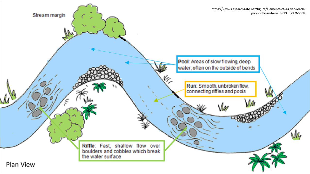
Figure 3: Examples of physical habitat components in a river (NPS-FM Appendix 1A – Compulsory values – 1 Ecosystem Health, Habitat). (Adapted from Fuller, J. E. (2018).)
Examples
The Rangitata River Water Conservation Order (2006) was created in part to recognise and protect the iconic braided character of the river – its natural form and character and the habitat it provides. It includes the clause:
9 Restrictions on alteration of river flows and form
(1) No resource consent may be granted or rule included in a regional plan that will cause the material alteration of the channel cross-section, or meandering pattern, or braided river channel characteristics of the form of any river specified in Schedule 2.
While this clause has not prevented encroachment, it provides an example of the wording that could be used in objectives and policies to guide the development of appropriate target attribute states and rule frameworks.
Case studies
The ecological effects of bed re-levelling on the Wairio Stream
This case study demonstrates the impact that drainage maintenance can have on freshwater species, if appropriate habitat is not provided for during and after works.
Environment Southland undertook a project to lower the Wairio Stream bed after local landowners complained about impeded drainage. The streambed had aggraded, resulting in backed up water at many adjacent farmland outlets. Monitoring pre and post work to determine the ecological impacts of the re-levelling activity found that the overall fish abundance, the number of brown trout (particularly adult trout) and the number of longfin eels had all significantly declined.
The likely cause for large brown trout decline is the re-levelling and removal of deeper pool and run habitat and the creation of more long, shallow, homogenous runs from the works. For future drain re-levelling projects, it was recommended that ‘some deep water habitat is created during the works, and that patches of large woody material are added to the channel to provide some habitat diversity’ (Dare & Allibone, 2016).
Can non-native perch support native eel populations in wetland complex?
This case study demonstrates that non-native perch are providing food for native fish populations in a wetland environment.
Research was conducted to explore the potential benefits that non-native perch (Perca fluviatilis) may provide to native fish populations – the endemic longfin eel (Anguilla dieffenbachii) and the native shortfin eel (Anguilla australis).
Although it is well recognised that non-native fish can become invasive and outcompete and displace native fish populations, this research found that in a wetland comprising both native and non-native species (Rakatu wetland), eel population density was three times higher than a neighbouring wetland which only contained native fish (Redcliff wetland). Young-of-the-year perch comprised ca. 40% of the eels’ diet at Rakatu wetland. At Redcliff wetland, juvenile eel density was four times lower, suggesting cannibalism may be occurring to support the existing eel population, and the presence of perch in a wetland may reduce eel cannibalism.
The research suggested that ‘freshwater managers consider the predator-prey dynamics of both native and non-native fish before removing non-native species, to avoid unintended negative consequences for native predatory fish species’ (Steward et al., 2023).
Evidence
[When available]
Resources
[When available]